|
| |
 The Romans were based around Battle in East Sussex at Beauport from 43AD
until 400AD. Here they built a bathhouse to provide the
troops guarding the Iron Workings ( bloomeries ) in the
area with recreational facilities. The Romans were based around Battle in East Sussex at Beauport from 43AD
until 400AD. Here they built a bathhouse to provide the
troops guarding the Iron Workings ( bloomeries ) in the
area with recreational facilities.
Battle was founded on the site of the Battle of Hastings
in 1066 , whose name comes from the Rape of Haestingas
(one of the six major divisions of the land of the South Saxons)
in which the Battle was fought. Hastings was the nearest small
town and a fishing port at this time, though larger than other
settlements in the area.
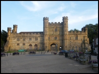
The town was originally known as La Bataillage which was built up
around Battle Abbey which was constructed between
1070-1094 by William the Conqueror , as a penance ordered
by the pope for the loss of life occurring in the battle,
and in earlier raids in the surrounding area designed to
draw Harold into conflict. (See Whatlington , Salehurst and
Mountfield )
King William II stayed at Hastings Castle in 1095 while he waited
for favourable seas to take him to France, during this time he
visited the newly formed Abbey at Battle .
As the town grew, the Abbot in 1115 built the church,
for the people of "Battel" a village which
had grown up around the Abbey.
1264 saw Henry III and his army stop at Battle on their way to
their defeat by Simon de Montfort at Lewes.
The abbey gatehouse was built in 1338 as a protection
from a possible French Invasion. To the side of these
gates stands the Pilgrims Rest, now a tea room/restaurant, the current building
was erected in 1420, on the site of a 12th century building.
The Benedictine Abbey became famous, and until the
dissolution by Henry VIII in 1538, the hub of a wide
sphere of influence.
The Abbey was given to Sir Anthony Browne who was Henry's
Master of the Horses, and was lived in and used as a
private estate until 1976 when it was purchased for the
nation by the government. It is now in the care of English
Heritage, and is a major tourist attraction, as the
battlefield and abbey can be visited. The main building
is a private school, but can be visited during school
holidays.
The area in front of the Abbey gates, is known as the Abbey
green, which was used for bull-baiting, a once popular
pastime, it is now a gravelled amenities area.
In the 17th century, Battle was the centre for the gunpowder
industry, located in the surrounding villages. The famous
Battel Bonfire Boyes celebrate the gunpowder plot in November,
it is possible that the gunpowder used by Guy Fawkes came
from this area.
This small town is the heart of the Sussex Bonfire Societies , who provide
noisy processions, unbelievable outfits and fantastic firework displays throughout
the month of November - a spectacle not to be missed. |
|
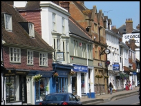
 There are a number of picturesque views in Battle in East Sussex. Walk
down the High Street from the north end of town near
the roundabout and in front of you is the old green, now
a car park, and behind that the Abbey Gates. There are a number of picturesque views in Battle in East Sussex. Walk
down the High Street from the north end of town near
the roundabout and in front of you is the old green, now
a car park, and behind that the Abbey Gates.
From the gates of Battle Abbey walk south past the Pilgrims Rest,
until you reach the gate to the field, turn right, and
a small footpath takes you back to the north of the town.
Along this path, facing south you can see the rolling
East Sussex landscape. The 1066 Country Walk runs through the town. |
|
 Battle in East Sussex has many shops, and is a centre for the local
villages.
The main London to Hastings railway stops
in the town with half hourly services taking about 1
hour and 20 minutes to London. Battle in East Sussex has many shops, and is a centre for the local
villages.
The main London to Hastings railway stops
in the town with half hourly services taking about 1
hour and 20 minutes to London.
It is a major stopping
route for buses that service the local area.
The nearest large town is Hastings about 3 miles South
which provides a major shopping centre, and many
Supermarkets.
Car parking is either behind the high street or just off
the main Battle roundabout, Battle Abbey has its own car park. |
|
| Battle is shown as the red symbol on the map. |
|
|
Nearby Villages
(click on symbol to see the village page) |
| Village= | |
Town= | |
Recorded in Domesday= |  |
| |
|
|
Ashburnham |
(Last Iron Furnace in Sussex) | | 4.05 miles |
|
|
Bodle Street |
(White Horse on the roof) | | 6.19 miles |
|
|
Boreham Street |
(Picturesque village on top of the Ridge) | | 5.83 miles |
|
|
Brede |
(Edward I inspects the Channel Fleet) | | 5.14 miles |
|
|
Brightling |
(famous for Mad Jack Fuller) | | 4.92 miles |
|
|
Broad Oak Brede |
(On the Crossroads) | | 5.47 miles |
|
|
Catsfield |
(Iron, Railways and Clocks) | | 1.96 miles |
|
|
Cripps Corner |
(Home Guard surprises the Army) | | 3.68 miles |
|
|
Crowhurst |
(Village devastated by the Normans) | | 2.52 miles |
|
|
Dallington |
(Custers Last Stand!) | | 5.89 miles |
|
|
Guestling |
(Changing guards at Buckingham Palace) | | 6.54 miles |
|
|
Hastings East Cliff |
(Beautiful Views and peaceful Walks) | | 6.71 miles |
|
|
Hastings Ore |
(Iron and the Turnpike) | | 6.38 miles |
|
|
Hooe |
(The Haunt of Smugglers) | | 4.81 miles |
|
|
Mountfield |
(17th Century Coal !!) | | 2.71 miles |
|
|
Netherfield |
(Village at the top of the Hill) | | 2.82 miles |
|
|
Ninfield |
(Last of the Iron Stocks) | | 3.36 miles |
|
|
Penhurst |
(Beautiful yet Remote) | | 3.28 miles |
|
|
Sedlescombe |
(Best gunpowder in Europe) | | 2.48 miles |
|
|
Staplecross |
(Mothers grudge hangs son) | | 4.53 miles |
|
|
Wartling |
(World War II defence centre) | | 6.92 miles |
|
|
Westfield |
(Bonfire Boys under suspicion) | | 3.97 miles |
|
|
Whatlington |
(King Harold's Manor) | | 1.81 miles |
|
|
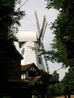
Windmill Hill |
(Largest Post Mill in Sussex) | | 6.62 miles |
|
|


